The Panama Canal
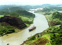 The Canal is both an engineering marvel and one of the most significant waterways on earth. Stretching 80km (50 miles) from Panama City on the Pacific coast to Colón on the Caribbean coast, it provides passage for over 12,000 oceangoing vessels per year. Seeing a huge ship nudge its way through the narrow canal, with vast tracts of virgin jungle on both sides, is an unforgettable sight. The easiest and best way to visit the Canal is to go to the Miraflores Locks, on the northeastern fringe of Panama City, where a platform offers visitors a good view of the locks in operation. There's also a museum with a model and a film about the Canal. Boats leave Balboa, a western suburb of Panama City, for a five-hour tour through the locks to Miraflores Lake. The Canal is both an engineering marvel and one of the most significant waterways on earth. Stretching 80km (50 miles) from Panama City on the Pacific coast to Colón on the Caribbean coast, it provides passage for over 12,000 oceangoing vessels per year. Seeing a huge ship nudge its way through the narrow canal, with vast tracts of virgin jungle on both sides, is an unforgettable sight. The easiest and best way to visit the Canal is to go to the Miraflores Locks, on the northeastern fringe of Panama City, where a platform offers visitors a good view of the locks in operation. There's also a museum with a model and a film about the Canal. Boats leave Balboa, a western suburb of Panama City, for a five-hour tour through the locks to Miraflores Lake.
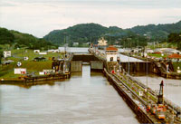 The Canal uses a system of locks - compartments with entrance and exit gates. The locks function as water lifts: they raise ships from sea level (the Pacific or the Atlantic) to the level of Gatun Lake (26 meters above sea level); ships then sail the channel through the Continental Divide. Each set of locks bears the name of the town site where it was built: Gatun on the Atlantic side, and Pedro Miguel and Miraflores on the Pacific side. The Canal uses a system of locks - compartments with entrance and exit gates. The locks function as water lifts: they raise ships from sea level (the Pacific or the Atlantic) to the level of Gatun Lake (26 meters above sea level); ships then sail the channel through the Continental Divide. Each set of locks bears the name of the town site where it was built: Gatun on the Atlantic side, and Pedro Miguel and Miraflores on the Pacific side.
The narrowest portion of the Canal is Culebra Cut, which extends from the north end of Pedro Miguel Locks to the south edge of Gatun Lake at Gamboa. This segment, approximately 13.7 kilometers long, is carved through the rock and shale of the Continental Divide. 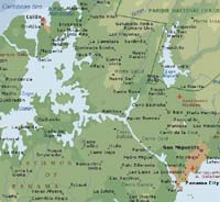 Ships from all parts of the world transit daily through the Panama Canal. Some 13 to 14 thousand vessels use the Canal every year. In fact, commercial transportation activities through the Canal represent approximately 5% of the world trade. Ships from all parts of the world transit daily through the Panama Canal. Some 13 to 14 thousand vessels use the Canal every year. In fact, commercial transportation activities through the Canal represent approximately 5% of the world trade.
Click the map to enlarge the map of the Panama Canal!
Interesting Panama Canal links:
The Panama Canal Museum
The Panama Canal Authority (ACP)
|